The Dalton can be done in 2 days but it completely depends on the road conditions. It'll take 2 days if the weather is fine and up to 5 if it's awful and you're just spinning your wheels. I asked the guys at the bike shop how the road was and most of them said I should be fine. 2 of the guys said I shouldn't go at all but I just figured they were Honda GoldWing riders so I didn't pay them much mind. I had enough food and water to last 3 days with me so if I run into any difficulties I should be okay for a little while. It really just all depends on the rain and I hadn't seen any yet so I figured I'd be okay.
The gas situation on the Dalton is interesting. You have to buy gas at the last legit gas station in town just to have enough to make it to Coldfoot. You have to buy gas at Coldfoot just to make it to Deadhorse and the same for the way back. The bike I'm riding carries more gas then most but that only buys me a little more room for error. Most bikes carry extra gas bottles with them just to make it the distances between stations. Each time you gas up you have to plan a turn around point half way because if you go 2/3rds of the way then decide the roads are too bad to continue you won't make it back to the next gas stop.
I topped off my tank and started up the road. The roads were made of really loose gravel and sand for the first half of the day. Some sections had just been rough paved by stimulus money, but construction trucks were everywhere trying to get a few more miles done before winter's grip put them all out of work. The deep gravel in the construction sites were challenging enough.
The Dalton has been around since the mid 70's and the fact that they're just now getting around to paving it is astounding. The difficulty lies in the permafrost. The ground up here is frozen solid. Trees have gone from 30ft tall giants further south to completely gone all together. The only thing that can grow are small shrubs and bushes that take 50 years to grow to be a foot tall. Temperatures dropped from the mid 70's to the mid 40's just in my first 150 miles of riding. I didn't bring much for winter clothing but then again I don't plan on spending much time up here.
The Dalton has been around since the mid 70's and the fact that they're just now getting around to paving it is astounding. The difficulty lies in the permafrost. The ground up here is frozen solid. Trees have gone from 30ft tall giants further south to completely gone all together. The only thing that can grow are small shrubs and bushes that take 50 years to grow to be a foot tall. Temperatures dropped from the mid 70's to the mid 40's just in my first 150 miles of riding. I didn't bring much for winter clothing but then again I don't plan on spending much time up here.
Mile after mile of slimy soft mud and loose gravel takes it's toll. I took regular breaks and continued the arduous task of climbing and descending the slippery and filthy mountains in the Kanuti Wildlife Refuge. By the time I reached my first 100 miles I was already exhausted, covered in mud and I still had 15 miles to go just to make it to the Arctic Circle. I don't remember crossing the Yukon river. The map says I did but I must have been too busy slipping and sliding all over the road or stuck in a fog bank at the time.
By the time I reached the Arctic Circle It must have been 3 or 4 in the afternoon. In all the days riding so far I haven't been on the bike this long and not been at least 400 miles down the road. The roads were just too slippery with all the gravel and too rough with all the pot holes to put on any kind of speed at all. At this point I've only done about 190 miles so far. The Arctic Circle turn out was done well. They had a nice sign to take pictures in front of and also some sign posts describing the animals, landscape and how the sun affects each of them. It actually seemed a little too nice for something that only a few people trek up to see every year. I wasn't shy about asking a passing trucker to take a few photos too commemorate the milestone.
I continued north another 80 or so miles past Gobblers Knob, Grayling Lake and then finally made it to Coldfoot. Coldfoot got it's name in the early 1900's because it marks the spot where the original gold rush prospectors got cold feet and turned around. I was having a tough time with the roads but wasn't nearly ready to turn around just yet. The road wasn't soaked enough for me to call it quits just yet. I wanted to see Sukakpak Mountain and Atigun Pass before I made camp somewhere. Sunlight was no longer an issue, apparently I would not be seeing night time until I got off of the mountain. I grabbed a cheeseburger and a beer at the truck stop and spent an hour chatting with a trucker about trucking of all things. He was more then happy to talk about work with me. I'm just glad we didn't start talking about my job.
Sukukapak mountain is a massive wall that juts out of the landscape to almost 5000ft right in front of the road. Luckily I was stopped at another construction site right in front of it and was able to catch a few photos during the wait.
The road bobbed and weaved around the Alaskan oil pipeline the entire way. Sometimes it was less than 20 yards away and sometimes it was a half mile in the distance. The pipeline would duck underground for a mile or two then pop up on the other side of the road. I was so busy starring at the scenery and concentrating on the road that when the pipeline would pop up next to me it would surprise me.
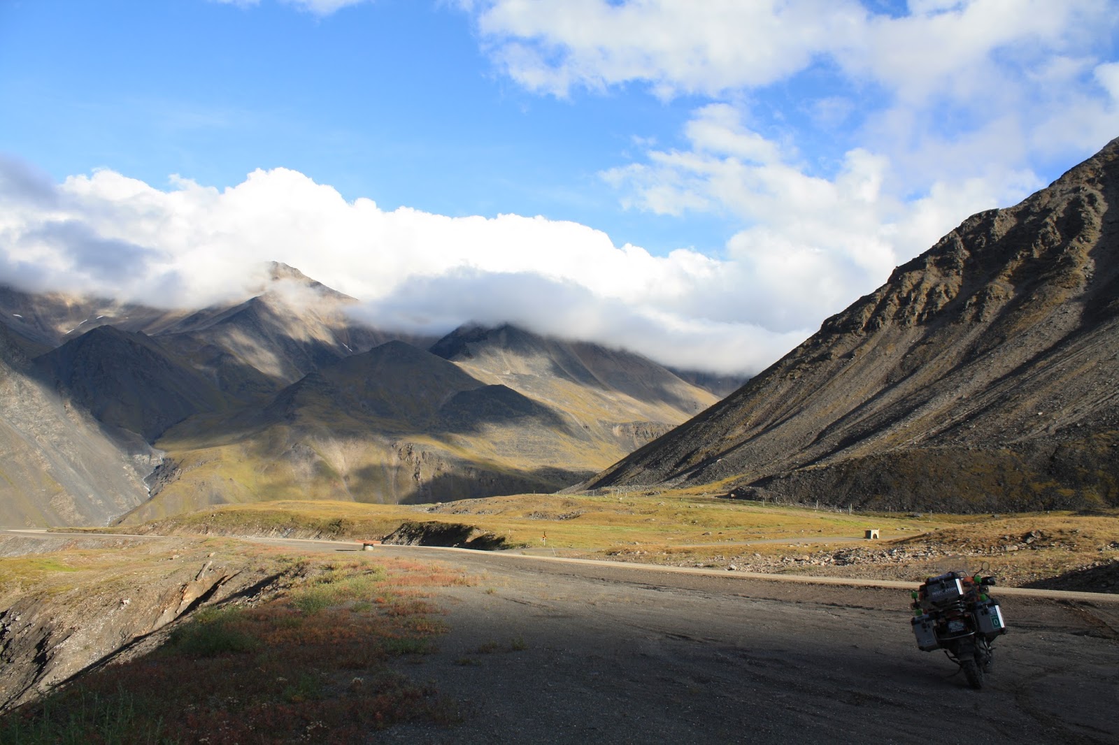
The ride up the Atigun pass was amazing. The mountain rises up out rolling hills to 5000 ft above sea level and it's a really steep too. I have no idea how the truckers make it up and down the pass without going over the edge every time. The guard rail was mangled in at least 8 different places, so that just proves to me that it was treacherous for them. I was spinning my rear tire most of the way just trying to keep momentum and stay straight. Atigun pass has been on that show Ice Road Truckers a few times. They respect the pass on that show and don't add extra drama like they do everywhere else it seems.
After Atigun the roads started to descend towards the Arctic in a really gradual way. I still had about 250 miles to go but my shoulders were tired from wrestling with the roads bumps and ruts. I pulled into a secluded spot in a valley called Galbraith Lake. What a spot! Gorgeous scenery and a nice cool breeze. I pulled in and set up shop at the end of the path. Within 3hrs I was sitting around a campfire with a cool German dude in his early 40's and his dog, and a Mongolian guy in his late 20's or early 30's. The German guy had traveled everywhere and absorbed as much culture and history as he could from his travels. He even knew interesting stories of even our own American history that they don't teach in schools. He also used to ride a bike like mine but traded it in for a truck when he got the dog Nu'ka. The Mongolian kid was also camping in the area. He was with his dad showing him around his new home state. He was a gold mine engineer at one of Alaska's modern mines. Who knew Colorado had a mining university?
We chatted for hours about travel, culture and the places we've been. The conversations were light and humorous and never got awkward or forced. We each had completely separate backgrounds and came from opposite sides of the globe but that night we were all friends camping under the midnight sun sharing a few beers and a box of wine around a fire. It was a really diverse group of strangers having a great conversation without any difficulty


 |
| this is as dark as it got |


Ride on, man! Those sights are stunning for a Washingtonian... I can't imagine what they're like to a Floridian!
ReplyDeleteGreat riding, writing and photography Dan! My dad worked two summers in the 70's on the pipeline as a bending operator!
ReplyDeleteI really enjoy reading your blog! Nice pictures too! Keep them coming. Did you end up getting into the ocean the next morning? We barely made it there on time. Like you said it was very cold and even driving was not pleasant. It was nice meeting you. Where are you headed now?
ReplyDeleteThe Mongolian